Wednesday, July 3, 2013

Clive Greenbelt Trail

Lynnea walking on the "trail"
To start off this blog we must say that we rode on this trail on the most perfect day! Sunny, low 70's, and our spirits were high.  We just randomly found this one in our book that we bought.  It is mostly shaded, cooler, travels alongside of Walnut Creek, buggy, forested, high traffic of people; bikers especially, and filled with nature.  In total we saw 3 does and 2 stags, and a beaver! The trail is very scenic and for most of it you forget that you are riding in an urban area.  It is composed of multiple bridges that connect to various neighborhoods, bends, natural and preserved prairie (cool), a few playgrounds along the path, patches or urban areas and it links up with Campbell Recreation Area which has a shelter, picnic areas, restrooms, parking and concessions.  Overall this trail is scenic, paved, good length for an out-and-back ride, and provides recreation of all kinds for everyone.  The really are only 2 negatives about it: high traffic of people and the trail heads are somewhat hidden from the main streets so they can be difficult to find.
There are a few different "trail heads" to choose from so we just chose the one closest to our apartment.  We started our journey at the West Trail Head.  And of course, because it is us, we started going in the direction where the trail ended about a mile down.  The tricky part about all of this is after our trail "stopped" the path kept going but there wasn't a sign or anything to tell us what trail we were currently on.  So we kept going and going through Clive, then through Windsor Heights, then Des Moines and finally we were in West Des Moines at the start of the Raccoon River Trail.  The trail to get to this point contained a detour route because of the construction on Grand Ave bridge.  Due to this there were a few rather steep hills added to our path that made things very challenging.  In the end though they were fun and worth it.  When we stopped in WDSM to find our barrings we ran into the QT nearby for some Gatorade and then headed back on the same path that lead us there.
Eventually we snaked our way back onto the Clive Greenbelt Trail and to our trail head.  We were feeling good still after riding nearly 11 miles so we kept going (left from the trail head instead of right this time).  This portion of the trail was very curvy  and the path had narrowed some making it difficult to go fast due to the large number of bikers and joggers that were also on the trail. We went a few miles down the path and then turned around.  At this point we ran into a large group of people that we named as the "biggest loser wannabes" because they all had matching shirts, they were all overweight and their shirt said "the gear challenge" or something like that.  They were super annoying only because there were about 12 of them in a somewhat spread out line.  Once we passed all of them we were almost back and we'd be safe and sound. THEN A DEER POKED OUT OF THE WOODS AND NEARLY KILLED US!!!! But for real it almost made me crash into Kathryn's bike and at the same time a small family was right behind me and almost crashed into me! It happened so fast that there really wasn't a chance for anyone to give the others any warning of stopping so abruptly.  Everyone was fine though so we continued and shortly after finished our ride.  In total we biked for 13.78 miles.  It wasn't super long but so far it our longest!  It takes time to get in biking shape but we'll work our way up to the big boys!

Trail Link: http://www.bandhtrails.com/dsm/trails/clivegreenbelt/

Friday, June 28, 2013

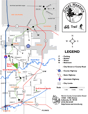
The Great Western Trail

Kathryn Holding Lynnea on  the bike
So we probably shouldn't even count this as biking the trail because we only biked 4 miles out and back of the 16.5 miles of the trail but we'll post about it for now.  I'm sure we will do the entire trail another time. To be honest we also really wanted to record another trail/entry, so here it is!

The Great Western Trail is a portion of what once was an old railroad built in 1899 that connected Kansas City, Chicago and St. Paul.  The portion of the trail that we went on was still within the Des Moines perimeter but we shortly left that and found ourselves in farm country, then a golf course and then back into the farmland/ prairie.  If we had gone further then we would have found ourselves in the wooded valley of North River.  From this trail you can also hook up onto the Lake Maffit Picnic Loop which is roughly 22 miles.  We hope to do that one soon.

The portion that we went on was very flat yet had a slight upgrade the entire way out making it necessary to pedal the entire time without coasting (that was tiring!).  The views were pleasant though with the forested portions next to the trail and the farmland and prairie just past that.  After we snapped a pic of our friend Lynnea (in gazelle form) we turned around and headed back to our Jeep.  The way back went faster because of the slight downgrade in elevation.  Sadly because we were going to fast I was unable to stop in time before a little squinny ran into my front tire, flipped, rolled and then ran away.  It was terrifying!  I'm not sure what became of that poor little chipmunk, but we both hope its ok.  Kathryn thinks that he ended up not getting hurt but of course I think that I killed him. RIP baby squinny :(  On a happier note though we saw a distant cousin of Lynnea's out on the trail; a cute doe.  She totally was unafraid of us while she stood there grazing.  Super cute! Then after she ran away we finished our short journey, went home and died because the sun was beating down on us the entire time.
Lynnea's distant cousin

Sorry you may have to download it to see it better

Wednesday, June 26, 2013

Neal Smith Trail

So we actually did this ride on Tuesday June 18th but we just started this blog and that wasn't too long ago so we will add it as our first post.  The Neal Smith trail actually starts as the John Pat Dorrian trail in Des Moines then runs north to connect to the Neal Smith.  As you bike along the path next to you is the Des Moines river for most of the route until the trail curves and you bike along the east side of Saylorville Lake. Eventually the trail ends at the Big Creek beach and marina in Big Creek State Park.  The length of the Neal Smith trail is 26 miles and the John Pat Dorrian trail is 2.2 miles.  You can also reach the Trestle to Trestle trail off the the Neal Smith which is 3.8 miles.

On one of the bridges in the more forested part of the trail.
Kathryn and I did not do the entire route.  We started from Cherry Glen Campground on the east side of Saylorville Lake and took the trail to the end (Big Creek beach and marina).  This portion of the trail had both open prairie and forested portions which contained winding turns, small hills, large drops, bridges and connections to many other campgrounds, boat docks and roads.  We both really enjoyed this trail. The forested portions were slightly shaded which was nice because it was close to 95 degrees Fahrenheit and not a cloud in the sky.  The open parts were really hot. The last few miles of the ride was mainly downhill and across a few bridges.  It was forested and high above the river.  Going over the bridges and being that exposed was kind-of scary but we quickly crossed it before we over-thought the situation.  The forest quickly turned into the open prairie again and we knew we were close to the end of the trail. Once we arrived to the beach and marina we stopped to take a break.  At that point we had biked 12 miles.  This also was our first bike ride so at this point we were really tired.  We then made hot dogs on a grill nearby and went kayaking on the lake.  After all of this excitement we caught a ride from a friend back to our campsite because we were too tired from the activities and drained from the sun.  Overall it was a great trail!

Here is the link to the trail: http://www.mvr.usace.army.mil/Portals/48/docs/Recreation/ODS/Maps/Saylorville%20Map.pdf